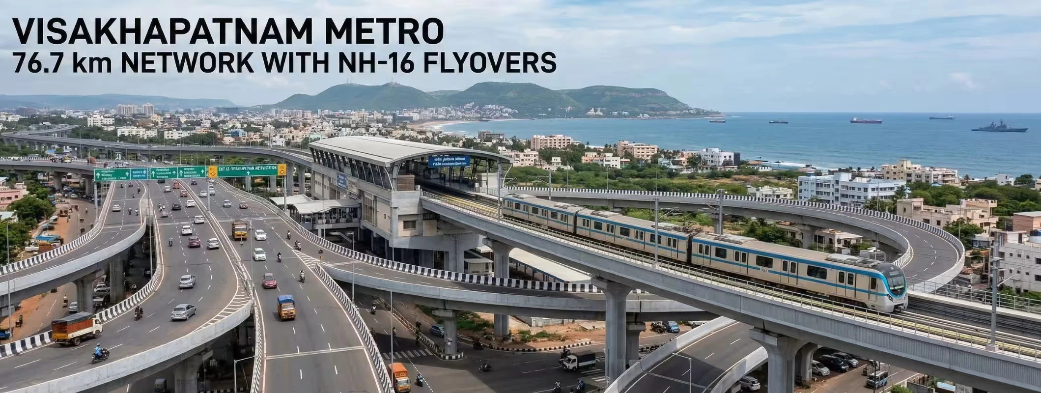
Visakhapatnam is moving toward a much bigger urban mobility story than a standard metro launch. The latest proposal discussed at the March 2026 CII meeting points to a broader four-corridor metro network of about 76.7 km to 76.9 km, along with 12 new flyovers along NH-16 to reduce traffic friction at major junctions. At the same time, the officially advancing Phase 1 is the more immediate piece on ground: 46.23 km across 3 corridors with 42 stations. That distinction matters because many headlines are mixing the long-term network vision with the phase that is currently closer to implementation.
For investors and homebuyers, this urban mobility expansion makes it an ideal time to buy land in Visakhapatnam, as improved connectivity and infrastructure are likely to boost property value and growth potential in both residential and commercial areas.
Key Takeaways
- 76.7 km is the broader proposed Vizag Metro network, not the same thing as the current active Phase 1 package.
- Phase 1 is 46.23 km, spread across three corridors with 42 stations.
- A double-decker metro-plus-flyover model is central to the project, especially along the highway-facing stretch.
- 12 NH-16 flyovers are being proposed to support smoother traffic flow where metro integration and road congestion overlap.
- For real estate, the biggest impact will likely be in connectivity-led micro-markets, not everywhere equally. Buyers should watch corridor-level execution, airport linkage, and junction-based growth carefully.
Visakhapatnam Metro at a Glance
| Item | What the Latest Reports say |
| Broader proposed network | 4 corridors, about 76.7 to 76.9 km |
| Active current phase | 46.23 km, 3 corridors, 42 stations |
| Key road integration | 12 new NH-16 flyovers proposed |
| Major feature | Double-decker flyover-cum-metro viaduct on key stretch |
| Current phase cost | Revised DPR around ₹11,498 crore to ₹11,500 crore; EPC civil tender earlier cited at ₹6,250 crore excluding GST |
| Future airport linkage | Kommadi to Bhogapuram is part of the longer vision and Phase II thinking |
Why This Project Matters
Vizag has been growing as a port city, industrial city, IT destination, and lifestyle market at the same time. That kind of expansion usually exposes the weak points in urban mobility first: choke points at junctions, longer commute times, and uneven access between business zones, residential clusters, and future infrastructure such as the Bhogapuram airport. The metro-plus-flyover model is designed to solve exactly that kind of layered congestion instead of relying on road widening alone.
The bigger story is not just that Vizag may get a metro. The real story is that planners are trying to build a multi-level mobility spine where metro movement and highway movement can coexist more efficiently. That is why the NH-16 integration piece stands out so much in current reports.
The 76.7 km Number Explained Properly
A lot of people are reading one headline and assuming the full 76.7 km network is already in execution. That is not the cleanest reading of the current situation.
Recent reports from the March 2026 CII discussion mention a four-corridor Visakhapatnam Metro network of roughly 76.7 km to 76.9 km. But the more concrete project package moving through approvals and project structuring is the 46.23 km Phase 1, which includes three corridors and 42 stations. The city’s long-term metro vision is larger, while the currently advancing phase is smaller and more implementation-ready.
That difference is important for investors, buyers, and even content creators. When people hear “76.7 km metro,” they may assume all connected localities will see immediate benefits. In reality, timelines, land acquisition, and phased development decide who benefits first.
Phase 1 Corridors That Matter Now
The current Phase 1 alignment covers Steel Plant Junction to Kommadi, Gurudwara to Old Post Office, and Thatichetlapalem to Chinna Waltair, bringing together industrial, residential, commercial, and city-core zones. The longest corridor is the Steel Plant–Kommadi stretch, which runs along the national highway side and is expected to use a double-decker model on a key section.
This matters because these are not random lines on paper. They touch or influence high-traffic and high-visibility areas such as Gajuwaka, NAD Junction, RTC Complex, Maddilapalem, Akkayyapalem, Daba Gardens, MVP Colony, Beach Road, and Chinna Waltair. In urban real estate, connectivity improvements around such nodes often create stronger demand attention than peripheral locations without access logic.
What the 12 NH-16 Flyovers Could Change
The proposal to add 12 flyovers along NH-16 is one of the most important parts of the story because it shows the state is thinking beyond rail in isolation. Reports indicate that major junctions such as Gajuwaka, Maddilapalem, Hanumanthawaka, and PM Palem are among the congestion-sensitive points being considered in the integration plan.
From a city-planning and real-estate angle, this has two direct implications. First, better junction handling can improve average travel reliability, which matters just as much as raw distance. Second, integrated road-and-metro planning usually makes certain corridors easier to market, easier to live in, and easier to evaluate for long-term end use. The winners are usually localities that gain both accessibility and daily usability.
Cost, Funding, and Timeline: What We Know So Far
The cost story also needs a clean explanation. The revised current-phase estimate has been reported at around ₹11,498 crore to ₹11,500 crore, while an earlier EPC civil tender package was reported at ₹6,250 crore excluding GST. These figures are not necessarily contradictions; they likely reflect different project scopes, with one tied more narrowly to the civil execution package and the other to the updated DPR-level cost.
Funding reports indicate a model involving 20% from the Union government, 20% from the Andhra Pradesh government, and the rest from international financing agencies, while earlier project material also mentioned possible support from institutions such as AIIB.
On timing, recent reporting said the Union government was expected to move toward in-principle approval of the revised DPR, and Phase II toward Bhogapuram would follow after the airport becomes operational. Separate January 2026 reporting around the Bhogapuram airport pointed to a June 26, 2026 opening target, although launch dates for large infrastructure projects can shift.
What This Means for Real Estate in Visakhapatnam
For property buyers, developers, and land investors, the project changes the conversation in three ways.
1. Connectivity will become a stronger valuation filter
Markets linked to metro corridors and decongested highway junctions usually attract more serious buyer interest than areas that remain dependent on slow, unpredictable road travel. In Vizag, that makes corridor-linked zones more important than generic “city growth” claims.
2. Airport-linked growth will gain more attention
The longer network vision includes the Kommadi to Bhogapuram airport corridor, which makes northern growth belts more relevant in long-term planning discussions. If airport operations and corridor execution move in the expected direction, investor attention could become more corridor-driven than city-wide.
3. Micro-market selection will matter more than hype
Not every property near a metro headline becomes a smart buy. The better approach is to check legal clarity, approach roads, land use, surrounding development, and realistic holding period. A metro announcement creates visibility, but execution quality creates value.
Where 2Bigha Fits Into This Story
2Bigha positions itself as a land marketplace focused on transparency, land listings, map-led discovery, and locality-level decision support. Its platform highlights land search, map exploration, locality insights, and property information that can help buyers compare opportunity zones more practically instead of relying only on market buzz.
For a market like Visakhapatnam, where infrastructure-led movement can shift demand toward specific corridors, platforms like 2Bigha fit best at the research and exploration of nearby properties and its development. Instead of asking, “Which area in Vizag might boom?” a better question is, “Which corridor has improving access, usable location logic, and cleaner decision data?” That is the kind of question a map-first, insights-led property search approach is better suited to answer.
Buyer Checklist Before Investing Near the Metro Corridors
Before making any land or property decision around the Vizag Metro story, check these points:
- Confirm whether the location benefits from the current Phase 1 or only the future expanded network.
- Verify whether the nearest access gain comes from metro alignment, NH-16 flyover decongestion, or both.
- Study the property’s real entry-exit convenience, not just map distance.
- Check land use, title, approvals, and surrounding planned development.
- Prefer a platform or advisor that gives location context, not just listing volume.
Final Word
The Visakhapatnam Metro story is worth watching, but it needs to be read correctly. The 76.7 km figure reflects the broader proposed network vision, while the 46.23 km, 42-station Phase 1 is the part that currently sits closer to real execution. Add the 12 NH-16 flyovers and the coming Bhogapuram airport connection, and Vizag starts looking less like a city solving today’s traffic and more like a city preparing for its next growth cycle.
For buyers and investors, that means one thing: do not chase headlines blindly. Track corridors, track execution, and track locality quality. And if you are trying to shortlist land or compare emerging zones with more clarity, 2Bigha fits naturally into that process as a property discovery and decision-support layer, especially when infrastructure-led growth starts redrawing the map.
FAQs - Visakhapatnam Metro
1. Is the Visakhapatnam Metro really 76.7 km long?
The broader proposed network discussed in March 2026 is about 76.7 km to 76.9 km across four corridors, but the currently advancing Phase 1 is 46.23 km across three corridors.
2. How many NH-16 flyovers are planned with the Vizag Metro?
Recent reports say 12 new flyovers along NH-16 are proposed as part of the larger integration strategy.
3. Which areas could benefit the most?
Corridor-linked areas around Steel Plant Junction, Gajuwaka, NAD Junction, RTC Complex, Maddilapalem, MVP Colony, Chinna Waltair, and the future airport-side growth belt near Kommadi–Bhogapuram are the most closely tied to the current discussion.
4. How does 2Bigha fit for property buyers?
2Bigha fits as a research and shortlisting platform for people who want location insights, map-led property discovery, and a more structured way to evaluate land opportunities around emerging infrastructure corridors, helping buyers invest in farmland more confidently.