Varanasi is expanding outward, and this time it’s not random growth. The Ring Road belt is turning into a planned urban corridor where new townships, commercial zones, and large-scale infrastructure are expected to cluster. The reason is simple: when a city gets a functional bypass + regulated planning, development naturally shifts to the edges where land is available and connectivity is stronger. This shift is also attracting investors and homebuyers looking to purchase land in Uttar Pradesh in emerging, well-connected locations rather than congested inner-city pockets.
What’s different right now is that the Varanasi Development Authority (VDA) has openly positioned the Ring Road corridor as the spine for “Greater Banaras” style township growth, with four townships planned along the Ring Road between Harahua and Rajatalab, spread across around 1,000 acres. The development is being supported under the Chief Minister’s Urban Expansion / New City Promotion scheme, giving stronger policy backing and clearer direction to this next phase of urban growth.
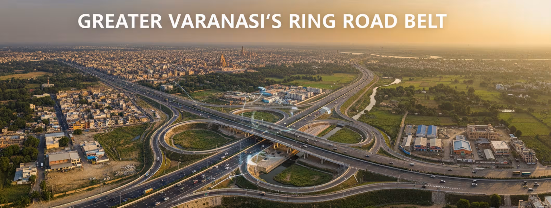
The 60-second snapshot (what’s actually happening)
- Ring Road Phase-I (16.55 km, 4-lane bypass) was inaugurated in November 2018, connecting NH-56 and NH-29—built to divert traffic and reduce congestion inside the city.
- Ring Road Phase-II Package-II is a 27 km package with a reported cost of about ₹1,992 crore (as listed in a MoRTH annexure).
- A key missing link has been the Ganga bridge under the Phase-II Package-II corridor. One side opened for light vehicles (reported June 2025), and the remaining work has been progressing with completion targets discussed by officials.
- On the urban planning side, VDA’s “Varanasi Master Plan 2031” documentation is available publicly, which matters because townships don’t grow in isolation, they follow zoning and development controls.
Why the Ring Road Belt becomes a “Township Belt” in every city
If you’ve tracked real estate in NCR, Jaipur, Lucknow, or Pune, you’ll notice a pattern:
- Ring roads reduce travel friction: They pull out-of-city traffic away from the core and create faster access to peripheral land parcels.
- Interchange points become micro-markets: Wherever highways meet, you get demand for fuel stations, warehousing, retail, small offices, and later—housing.
- Old city stays heritage-heavy, new city absorbs growth: Varanasi’s historic core has limits (heritage, density, roads, parking). Growth needs a newer canvas. That canvas is the periphery.
That’s why the phrase “Ring Road belt” is not just an infrastructure term anymore, it’s a real estate geography.
What “Greater Varanasi / Greater Banaras” means on the ground
The VDA media coverage lays out a clear direction: a planned expansion zone along the Ring Road with township-scale development, positioned somewhat like the “Greater Noida model.” It also mentions the kind of ecosystem expected that is markets, malls, hotels, hospitals, plus broader employment creation and decongestion of the old city.
Just as important: the scheme mechanics are not “builder-only.” The coverage explains that under the CM scheme, development authorities can arrange funds and acquire land through a defined framework.
Where New Townships are likely to take shape?
Based on what’s officially stated, the most important belt to watch is:
Harahua ↔ Rajatalab (Ring Road corridor)
VDA’s coverage directly calls out this stretch for the proposed township development and mentions four townships along this belt.
In practical terms, township development doesn’t appear as one big launch on Day 1. It usually moves in this order:
- Road connectivity + service roads + junction improvements
- Utilities planning (drainage, water, power, sewage systems)
- Layout approvals and zoning clarity
- Phased housing + commercial + institutional parcels
That’s why early-stage “investment plots” can be risky if they’re not aligned with approvals and zoning.
The planning twist most people miss: the Ring Road green belt rule
This is a big one, and it directly impacts buyers and landowners.
A recent report states VDA proposed a 20-meter green belt on both sides of the 60-meter-wide Ring Road, where permanent construction is prohibited, with limited exceptions (parks, playgrounds, certain public/eco-friendly uses, etc.). It also says construction near these roads should happen only after approvals, and unauthorized construction may face action under planning law.
What this means for you
- “Ring Road-touch” land is not automatically “best land.”
- If your plot falls inside restricted green belt zones, your construction options can be limited.
- Zoning + setbacks + approvals matter more than WhatsApp claims like “Ring Road se 200 meter.”
If you’re planning to buy, check the VDA Master Plan 2031 zoning documents and the relevant development controls.
Infrastructure momentum: why travel time change matters for property
When one side of the Ganga bridge opened for light vehicles, reports highlighted a major travel-time reduction between Varanasi and Chandauli. That kind of time-saving changes how people value peripheral land because:
- daily commute feasibility improves,
- freight movement becomes easier,
- “distance” feels shorter than it looks on a map.
And once heavy vehicles and full operations stabilize, bypass traffic reduces pressure on internal roads, making the city’s core less chaotic and the periphery more desirable.
Who should consider the Ring Road Belt?
You should seriously consider it if you are:
- An end-user planning to live outside the old city (more space, better access, newer layouts)
- A long-term investor who can hold through infrastructure completion and planning approvals
- A business buyer looking for visibility + connectivity (warehousing, hospitality, retail formats near growth nodes)
You should avoid it if you are:
- Looking for “quick flip in 3–6 months”
- Buying based on “future plan” without checking zoning/approvals
- Purchasing plots in areas known for illegal plotting or unclear land title chain
Due Diligence Checklist (don’t skip this in Varanasi belt deals)
Before you pay even ₹1:
- Land title chain: ownership continuity, mutation, any disputes
- Land category: agricultural vs abadi land vs land-use conversion requirements
- Zoning confirmation: verify in VDA Master Plan 2031 documents
- Approval status: check if it’s part of an approved layout / group housing / colony (VDA publishes approval-related lists and information)
- Green belt / road control impacts: confirm if any portion falls under restricted zones along Ring Road and major roads
- Approach road clarity: “kacha rasta” vs legally accessible approach
- Registry + stamp duty costs: budget your total acquisition cost properly
What to Expect Next
From official direction, the next 12–24 months usually show:
- survey + acquisition + layout planning (VDA already indicates survey and acquisition roadmap in the Greater Banaras plan coverage)
- more clarity on zoning, green belts, and approvals as development controls tighten
- gradual “node development” around key road links as Ring Road packages stabilize
FAQs - Greater Varanasi’s Ring Road Belt
Is the Ring Road belt a good place to invest in Varanasi?
It can be, if your land is aligned with zoning and approvals. The belt has strong infrastructure tailwinds, but VDA’s green belt and approval requirements mean you can’t treat every Ring Road-adjacent plot as construction-ready.
What is “Greater Banaras”?
A planned township-led expansion along the Ring Road, where VDA has indicated multiple townships between Harahua and Rajatalab, supported under a state urban expansion scheme, with a defined survey and acquisition process.
What’s the single biggest risk buyers face in this belt?
Buying into illegal plotting or land that looks premium on location but is restricted by zoning/green belt controls or lacks approval.
How do I verify zoning quickly?
Start with VDA’s publicly listed Master Plan 2031 resources, then confirm plot-level applicability through local verification and competent professionals.
Bottom Line
Greater Varanasi’s Ring Road belt is not a “rumour market” anymore. It now has:
- Real infrastructure movement (Ring Road phases + bridge link)
- A stated township direction under the Varanasi Development Authority (VDA) and state planning
- Tighter planning rules that make due diligence non-negotiable
This shift also means landowners are increasingly choosing to sell land online to reach serious buyers, while investors are focusing more on verified listings and proper documentation before making any commitment in this fast-evolving corridor.