Key Takeaways
- A cadastral map is a land parcel map that shows plot boundaries, parcel numbers, area, and adjoining land details. For land buyers, it helps confirm whether the plot shown on-site matches the official revenue map.
- Cadastral maps are important for land boundary verification India, land title checks, plot demarcation, mutation updates, tax assessment, land-use planning, and dispute prevention.
- In India, cadastral maps are closely linked with land records such as Record of Rights, jamabandi, khatauni, khasra/survey number, mutation records, and sale deeds.
- The Government of India’s Digital India Land Records Modernization Programme includes digitization of cadastral maps and integration of textual Record of Rights with spatial cadastral maps as key activities.
- As of the Government’s 2024 year-end review, 95% of Maps/Field Measurement Books had been digitized, and cadastral maps had been linked to Record of Rights in 72% of villages in India.
- Before buying land, buyers should not rely only on a seller’s location pin, broker statement, or property listing. Always match the cadastral map, land ownership records, sale deed, mutation record, encumbrance certificate, and physical site boundaries.
- Platforms like 2Bigha.ai help buyers explore land through map-based search, land price visibility, property insights, and land-focused listings. Sellers can also use the 2Bigha subscription plan for search visibility, seller dashboard access, buyer contact support, unlimited listings, and featured listing benefits.
Introduction: Why Cadastral Maps Matter in Land Buying
Buying land in India is not like buying a ready flat in a gated society. In a flat purchase, you usually check the builder, RERA status, carpet area, agreement, possession timeline, and approvals. But in land buying, the risk sits directly on the ground.
The seller may show you a beautiful farmland parcel. The broker may send a Google Maps pin. The boundary may look clear because someone has placed stones, fencing, or temporary poles. But the real question is different:
Is this exact land parcel legally recorded in the seller’s name, with the same boundary, same area, same survey number, and clear access?
That is where a cadastral map becomes important.
A cadastral map helps buyers understand the official layout of land parcels in a village, town, or revenue area. It shows where one parcel ends and another begins. It also helps connect the physical plot with official land records.
For anyone planning to buy agricultural land, farmhouse land, rural plots, investment land, or large parcels near highways and expanding cities, a cadastral map is not optional. It is one of the most important tools for property due diligence in India.
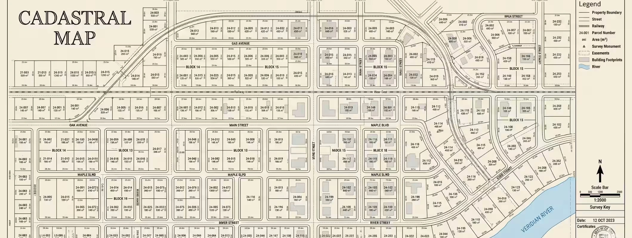
What is a Cadastral Map?
Cadastral Map Definition: Cadastral maps are legal maps of parcels of land that include the boundary limits, geographical location, parcel number, total area, and neighboring plots of land in a particular revenue jurisdiction.
In simpler terms, these maps are used to divide land into parcels or plots. These plots are normally accompanied by a survey number, khasra number, plot number, or any unique number provided by the concerned state government.
A cadastral map may show:
- Land parcel boundaries
- Plot or survey numbers
- Khasra numbers in many states
- Area of each land parcel
- Adjacent plot details
- Roads, pathways, canals, water bodies, or public land
- Village or revenue boundary
- Land ownership record references
- Subdivision or merger of plots
In India, cadastral maps are part of land administration and revenue records. They support ownership identification, land taxation, mutation, planning, dispute resolution, and registration-related checks.
The National Informatics Centre’s Bhu-Naksha platform describes Bhu-Naksha as a tool created for parcel map management, especially for state and UT officials handling land map records.
Why Should Land Buyers Care About Cadastral Maps?
A land buyer does not need to become a surveyor. But every serious buyer should understand how cadastral maps protect them from wrong land deals.
A cadastral map helps you answer these important questions:
- Is the plot physically shown to me the same parcel recorded in government records?
- Does the plot boundary match the official land parcel map?
- Is the land area correct?
- Does the plot have legal road access?
- Are neighbouring land parcels clearly identifiable?
- Is there any sign of encroachment or boundary overlap?
- Has the land been divided, merged, or mutated recently?
- Is the seller selling the complete parcel or only a share?
- Does the sale deed match the survey/khasra number?
- Can this land be safely purchased, sold, financed, or developed?
This is why buyers searching to buy land with a verified cadastral map, land ownership map verification, or check plot map before buying are asking the right questions.
A low-priced plot with unclear boundaries is not a bargain. It is a risk.
Cadastral Map Uses in Real Estate and Land Buying
Cadastral maps are used by government departments, surveyors, landowners, farmers, developers, legal consultants, banks, and land buyers. For buyers, their value is practical and direct.
1. Land Boundary Verification
The biggest use of a cadastral map is boundary verification. It helps you see the official boundary shape of a land parcel. This matters because the physical boundary shown on-site may not always match government records.
For example, a seller may show you a fenced rectangular plot. But the cadastral map may show an irregular parcel with a different orientation. If you ignore this mismatch, you may later face neighbour disputes, encroachment claims, or measurement problems.
2. Plot Identification
A cadastral map helps identify the correct plot using a survey number, khasra number, or plot number. This is especially important in villages where multiple plots may look similar on the ground.
Without map verification, a buyer may accidentally inspect one parcel and purchase another.
3. Ownership Record Matching
A cadastral map in itself cannot be used as proof of ownership. However, it serves as a means by which the land parcel can be matched against records of ownership like the Record of Rights, jamabandi, khatauni, 7/12 extract, RTC/Pahani, patta, or others that may be specific to the State concerned.
DILRMP is primarily concerned with the modernization of land record management.
4. Mutation and Subdivision Verification
If there is an acquisition, inheritance, partition, or transfer of any plot of land, then the mutation documents must include the recent revenue details. A cadastral map would enable prospective buyers to determine whether a plot has been sub-divided.
This becomes necessary especially while purchasing a part of a larger plot.
5. Access Road Verification
A plot without legal access can become difficult to use, resell, mortgage, or develop. A cadastral map may help identify whether there is a recorded road, rasta, public path, or access strip near the land.
Do not depend only on a visible dirt road. Check whether access exists in official records.
6. Encroachment Risk Check
Cadastral maps help identify whether the land boundary overlaps with neighbouring land, government land, water bodies, forest land, common land, or road widening areas.
For large land purchases, a proper site survey and demarcation should support the map check.
7. Land Use and Planning
Cadastral maps support land-use planning by showing parcel-level land structure. Developers, investors, and property legal consultants use these maps to assess road connectivity, parcel shape, nearby settlement, public land, and development potential.
8. Dispute Prevention
Many land disputes start with unclear boundaries. When buyers verify cadastral maps, revenue maps, land ownership records, and physical boundaries before purchase, they reduce the risk of future legal conflict.
Cadastral Map vs Survey Map: What is the Difference?
Many buyers use the terms cadastral map and survey map interchangeably. They are closely related, but they are not always the same.
Point | Cadastral Map | Survey Map |
Meaning | A land parcel map showing boundaries, parcel numbers, and revenue details | A map prepared through a land survey showing measurements, features, or boundaries |
Main Purpose | Land ownership, revenue record, taxation, parcel identification, land administration | Measurement, demarcation, layout, construction, planning, or boundary fixing |
Used By | Revenue department, land records department, buyers, legal consultants, surveyors | Licensed surveyors, engineers, developers, landowners, government departments |
Buyer Use | To identify official land parcel and verify boundaries | To measure land physically and confirm actual ground position |
Legal Value | Important for land record verification, but must be matched with ownership documents | Useful for technical verification, especially if prepared by authorized surveyor |
Example | Village cadastral map showing khasra/survey parcels | Demarcation survey map prepared after field measurement |
Simple Explanation:
A cadastral map shows how land parcels are officially recorded. A survey map shows how land is measured or mapped through survey work. For safe land buying, you may need both.
Also Read: Role of GIS Mapping in Modern Land Investment
Cadastral Map vs Google Map: Do Not Confuse the Two
Many buyers make this mistake. They see a property location on Google Maps and assume the boundary is verified. That is risky.
Point | Cadastral Map | Google Map |
Shows legal parcel boundary | Yes, based on land record map data | No, not legal proof of plot boundary |
Shows survey/khasra number | Usually yes, depending on state portal | No |
Helps with ownership record matching | Yes | No |
Useful for navigation | Limited | Very useful |
Useful for nearby landmarks | Limited | Very useful |
Can replace legal verification | No | No |
Buyer Risk If Used Alone | Some risk if not matched with records | Very high risk |
Google Maps can help you reach the location. A cadastral map helps you understand the official parcel. Both are useful, but they solve different problems.
How to Read a Cadastral Map
At first glance, cadastral maps can look confusing. They may show irregular shapes, small numbers, old village boundaries, pathways, water channels, and many adjoining parcels. But once you understand the basics, reading them becomes easier.
1. Start With the Village or Revenue Area
Cadastral maps are usually linked to a village, revenue village, ward, taluk, tehsil, or district. Always confirm the correct village name first. The same survey number or plot number can exist in different villages.
2. Find the Survey Number or Khasra Number
The most important detail is the parcel identification number. In northern states, this may be a khasra number. In southern and western states, it may be called survey number, GAT number, plot number, or another local term.
3. Look at the Plot Shape
Check whether the plot is rectangular, triangular, narrow, irregular, long, or divided into pieces. Shape matters because it affects access, fencing, cultivation, construction, resale, and usability.
4. Check Adjacent Parcels
Neighbouring parcel numbers help confirm whether the land shown physically is the correct land. They also help identify potential boundary disputes.
5. Check Road or Path Access
Look for roads, village paths, cart tracks, government routes, or access strips. If there is no recorded access, ask for clarification before paying any token amount.
6. Compare the Area
Match the area shown in the cadastral map with the sale deed, revenue record, seller document, and physical measurement. Small differences may happen due to old surveys or rounding, but major differences need professional review.
7. Match With Ownership Records
A cadastral map is incomplete without ownership records. Always match it with Record of Rights, mutation records, sale deed, and encumbrance certificate.
How to Check Cadastral Map Online in India
The process changes from state to state because land is a state subject in India. However, the general online checking process is similar.
Step 1: Visit the Official State Land Records Portal
Search for your state’s official land records portal, Bhu Naksha portal, revenue map portal, or cadastral map portal. Avoid relying on random screenshots shared by a seller or broker.
Step 2: Select Location Details
Most portals ask for:
- State
- District
- Tehsil/Taluk
- Village
- Survey number or khasra number
- Khata/khatauni/khewat number, if applicable
Step 3: Open the Plot Boundary Map
Once the village map opens, locate the relevant plot or land parcel. Some portals allow clicking on the parcel to view map details.
Step 4: Download or Save the Map Report
If the portal allows, download the map report. Keep it in your due diligence file.
Step 5: Match With Revenue Records
Compare the map with land ownership records, mutation details, sale deed, and physical site boundaries.
Step 6: Verify on Ground
Visit the site with a local surveyor, patwari, lekhpal, revenue official, or land verification consultant if the deal value is high.
Important Documents to Check With a Cadastral Map
A cadastral map is powerful, but it is not enough on its own. Before buying land, check the full document set.
Land Buyer Document Checklist
Document | Why It Matters |
Sale deed/title deed | Confirms registered ownership transfer |
Mother deed/title chain | Shows previous ownership history |
Record of Rights/Jamabandi/Khatauni/RTC/7/12 extract | Confirms current revenue ownership details |
Mutation record | Shows whether ownership change is updated in revenue records |
Cadastral map/revenue map | Confirms plot boundary and parcel location |
Survey/khasra number details | Confirms exact land parcel identity |
Encumbrance Certificate | Helps check loans, charges, or registered liabilities |
Tax receipts | Supports possession and payment history |
Demarcation report | Confirms physical ground boundary |
Land-use certificate/zoning check | Confirms whether the land can be used for intended purpose |
Conversion order, if needed | Required if agricultural land is converted to non-agricultural use |
Court/dispute search | Helps identify litigation risk |
NOC, if applicable | Needed for certain land types or restricted areas |
Road access proof | Confirms legal entry to the plot |
For a legal land document check, do not skip title review. A map can show where the land is, but title documents show who has the legal right to sell it.
Importance of Cadastral Map for Land Buyers
1. It Helps You Avoid Buying the Wrong Plot
This happens more often than people think. A buyer sees one plot and later discovers that the registered land is somewhere else. A cadastral map reduces that risk.
2. It Confirms Land Boundaries
Boundary confusion is one of the biggest reasons for land disputes. A cadastral map gives you an official starting point for plot boundary verification.
3. It Supports Legal Due Diligence
Legal experts, surveyors, and land records consultants use cadastral maps to compare land documents with actual site conditions.
4. It Helps Confirm Access
A plot may have physical access today, but if the access road is private or disputed, problems can arise later. Cadastral maps help identify whether road access exists in official records.
5. It Improves Resale Confidence
Land with clear boundaries, proper records, and verified parcel identity is easier to sell. Buyers prefer land with clear boundaries, plot with approved documents, and buy land with clear title options.
6. It Helps Banks and Investors
For larger transactions, banks, investors, and legal teams often review land records, maps, boundaries, and title documents before financing or investing.
7. It Reduces Fraud Risk
The DILRMP aims to make land records and registration information available online, helping check fraudulent or benami transactions and reduce land disputes.
Common Problems Found During Cadastral Map Verification
1. Boundary Mismatch
The land shown on-site does not match the official map boundary.
2. Area Difference
The seller claims one area, but the map and revenue record show another.
3. Wrong Survey Number
The plot being shown belongs to a different survey or khasra number.
4. Joint Ownership
The land is recorded under multiple owners, but only one person is trying to sell it.
5. Unupdated Mutation
The seller has a sale deed but mutation is not updated in revenue records.
6. Encroachment
A neighbour, road, fence, or structure overlaps with the land parcel.
7. Landlocked Parcel
The cadastral map does not show legal road access.
8. Government or Common Land Overlap
The land may touch or overlap with gram sabha land, forest land, pond land, road land, or reserved land.
9. Old Map, New Ground Reality
Some maps may be old or not fully updated after subdivision, acquisition, road widening, inheritance, or mutation.
10. Broker-Created Confusion
The broker may not intentionally cheat you, but they may not fully understand survey maps, khasra numbers, or legal land records.
Red Flags Buyers Should Never Ignore
Red Flag | What It Could Mean |
Seller refuses to share survey number | Hidden title or parcel identity issue |
Cadastral map and site boundary do not match | Wrong plot or encroachment risk |
Area differs heavily across documents | Measurement or title issue |
No legal access road | Landlocked property risk |
Mutation is pending for years | Revenue record problem |
Multiple owners but only one seller | Consent issue |
Land is under family partition | Future dispute risk |
Seller pushes fast token payment | Buyer may be pressured before due diligence |
Plot is very cheap compared to nearby land | Hidden legal, access, or title issue |
Land-use is unclear | Development or conversion risk |
If you find one red flag, verify deeper. If you find multiple red flags, pause the deal.
Cadastral Survey Process: How Boundaries are Verified
A cadastral survey is the technical process of measuring and identifying land parcel boundaries. The exact process depends on the state, land type, local revenue rules, and survey technology used.
A typical cadastral survey process may include:
- Collecting old land records and maps
- Identifying survey/khasra numbers
- Visiting the site
- Locating boundary marks or reference points
- Measuring parcel dimensions
- Checking neighbouring parcels
- Comparing field measurement with revenue map
- Preparing demarcation or survey report
- Updating records if mutation/subdivision is involved
For high-value land, always take help from authorized land survey experts or revenue officials. A casual tape measurement by the seller is not enough.
Online Cadastral Maps and Digital Land Records in India
India has been moving toward digitized land records, online access, and better integration of textual and spatial land data. Under DILRMP, the Government has listed digitization of cadastral maps and integration of Record of Rights with cadastral maps as key components.
The Government has also launched the NAKSHA programme under DILRMP for creation of urban land records as a pilot in 150 cities, with the stated aim of bringing clarity to ownership and helping solve land-related disputes in urban areas.
This is a positive direction for buyers. But buyers should still understand one thing clearly:
Digital access improves transparency, but it does not remove the need for legal due diligence.
Online maps may help you check plot boundaries faster, but final purchase decisions should still depend on legal title, revenue records, mutation, encumbrance check, site survey, and professional advice.
How 2Bigha Helps Buyers and Sellers in Land Discovery
Land buying is still fragmented in India. Many buyers depend on local brokers, scattered WhatsApp images, incomplete site details, and unclear price expectations. This makes decision-making difficult, especially for farmland, agricultural land, farmhouse plots, and investment land.
2Bigha helps simplify land discovery by allowing users to search land, explore current land prices, view promising investment opportunities, check land ownership-oriented insights, and access valuable property information for better decisions.
For buyers, this means better visibility before a site visit. You can explore land options with a map-first mindset instead of blindly depending on word-of-mouth.
For sellers, brokers, agents, and landowners, the 2Bigha subscription plan can support stronger property visibility. The subscription page mentions features such as search visibility, seller dashboard, buyer contact access, unlimited listing, featured listing, Pro Agent Sticker, social media post options, and WhatsApp support depending on the plan.
This is useful for people who want to sell legal property, promote verified plots for sale, or reach serious land buyers outside the local market.
Still, buyers should complete their own legal verification before purchase. A good platform can improve discovery and transparency, but the final land transaction should always be backed by document verification, cadastral map checks, and legal review.
Cadastral Map Verification Before Buying Land: Step-by-Step Buyer Process
Step 1: Collect the Basic Land Details
Ask the seller for:
- State, district, tehsil/taluk, village
- Survey number/khasra number
- Plot number, if applicable
- Khata/khatauni/khewat details
- Total land area
- Owner name as per revenue record
- Sale deed copy
- Mutation entry
- Cadastral map or Bhu Naksha copy
Step 2: Check Online Land Records
Use the official state portal to verify land records online. Match the owner name, survey number, area, and land classification.
Step 3: Check the Cadastral Map
View the parcel boundary online if the state provides map access. Check the plot shape, adjoining parcels, access road, and area.
Step 4: Compare With Physical Site
Visit the land. Do not just stand at one corner. Walk the boundaries, observe access, check fencing, speak to neighbouring landowners, and compare the site with the map.
Step 5: Verify Title Documents
Ask a real estate legal advisor to verify the title chain, sale deeds, inheritance documents, partition records, and ownership rights.
Step 6: Check Encumbrance and Litigation
Check whether there is any loan, charge, court case, acquisition notice, or registered restriction on the property.
Step 7: Confirm Land Use
If you are buying agricultural land for farmhouse, plotting, warehouse, resort, or commercial use, confirm whether conversion or approval is required.
Step 8: Request Demarcation if Needed
For large land parcels or disputed boundaries, request official demarcation through the revenue department or authorized surveyor.
Step 9: Pay Only After Verification
Do not pay a large token amount until the land passes basic document and boundary checks.
Step 10: Register Properly
Use proper payment trail, agreement terms, registered sale deed, stamp duty compliance, and mutation follow-up after registration.
Buyer Checklist: Cadastral Map and Land Record Verification
Use this checklist before buying land.
Checkpoint | Yes/No |
| |
| |
Have you viewed the cadastral map or Bhu Naksha? | |
Does the physical land match the official map boundary? | |
Does the area match across documents? | |
Is the seller the recorded owner? | |
Are all co-owners ready to sign? | |
Is mutation updated? | |
Is there legal road access? | |
Is there any encumbrance or loan? | |
Is there any court case or dispute? | |
Is land use suitable for your purpose? | |
Is conversion required? | |
Have you checked tax receipts? | |
Have you consulted a legal expert? | |
Have you completed site demarcation if needed? |
Who Should Use Cadastral Map Services?
Cadastral map services are useful for:
- Individual land buyers
- Agricultural land investors
- Farmhouse buyers
- Developers
- Builders
- Real estate agents
- Landowners
- NRIs buying land in India
- Banks and lenders
- Legal consultants
- Property document verification teams
- Land survey experts
If the land deal involves high value, inherited ownership, agricultural conversion, road access issues, family partition, or unclear boundaries, hire a land verification consultant before purchase.
Final Thoughts
A cadastral map is not just a technical land record. For a buyer, it is a protection tool.
It helps you confirm the plot boundary, identify the right survey number, match ownership records, check neighbouring parcels, understand access, and reduce future dispute risk. In a land market where many deals still depend on local networks and verbal claims, cadastral map verification brings structure and clarity.
Before you buy land, remember this simple rule:
Never buy land only because it looks good on-site. Buy land only when the map, documents, ownership, access, and boundaries match.
If you are exploring farmland, agricultural land, or investment plots, platforms like 2Bigha can help you discover land options through map-based listings and property insights. Sellers can also use the 2Bigha subscription plan to improve visibility and connect with serious buyers. But the final purchase should always go through proper cadastral map verification, legal land document checks, and on-ground due diligence.
A secure land investment starts with clear boundaries.
FAQs on Cadastral Map
1. What is a cadastral map?
A cadastral map is an official land parcel map that shows boundaries, plot numbers, survey numbers, area, and adjoining land details. It helps identify land parcels and supports land record verification.
2. Why is a cadastral map important for land buyers?
A cadastral map helps buyers verify plot boundaries, confirm the correct survey number, check road access, compare land area, and match the physical plot with official land records.
3. Is a cadastral map proof of ownership?
No. A cadastral map helps identify land boundaries and parcel details, but it is not complete proof of ownership. Buyers must also check sale deeds, Record of Rights, mutation records, encumbrance certificate, and title history.
4. How can I check a cadastral map online in India?
You can check cadastral maps through official state land record portals, Bhu Naksha portals, or revenue map portals where available. Select the district, tehsil, village, and survey/khasra number to view the land parcel map.
5. What is the difference between a cadastral map and a survey map?
A cadastral map shows official land parcel boundaries and revenue details. A survey map is prepared through measurement and may show actual ground dimensions, boundary marks, and site features. Both can support land verification.
6. Can I use Google Maps instead of a cadastral map?
No. Google Maps helps with location and navigation, but it does not prove legal plot boundaries or ownership. For land buying, use cadastral maps, revenue records, and legal documents.
7. What documents should I check with a cadastral map?
Check the sale deed, title chain, Record of Rights, jamabandi or khatauni, mutation record, survey/khasra number, encumbrance certificate, tax receipts, land-use documents, and demarcation report if needed.
8. What is plot boundary verification?
Plot boundary verification is the process of checking whether the land shown on-site matches the official cadastral map, survey record, revenue map, and legal documents.
9. Should I hire a land survey expert before buying land?
Yes, especially for high-value land, agricultural land, disputed land, inherited property, unclear boundaries, or land with subdivision issues. A survey expert can help with measurement and demarcation.
10. How does 2Bigha help in land buying and selling?
2Bigha.ai helps buyers explore land through map-based search, land price insights, and land-focused listings. Sellers, agents, brokers, and landowners can use the 2Bigha subscription plan to improve listing visibility and connect with more serious buyers.