Key Takeaways
- Bhu Naksha Chandigarh helps users understand land parcel location, plot boundaries, and map-based land details before buying or selling property.
- Chandigarh’s official land record system is managed through the Chandigarh Revenue Department and related digital initiatives such as LandStack, which connects land/property data with GIS-based maps and unique land parcel identity.
- The Chandigarh Revenue Department states that users can access land records such as Registration, Mutation, and Jamabandi, and view sanctioned mutations and Jamabandi using owner name, khewat number, and khasra number.
- Land maps are useful for checking plot location, boundary shape, village parcel identity, and mismatch between physical site and official records.
- For final property purchase, do not rely only on an online map. Always verify RoR/Jamabandi, mutation, registry, site boundary, and legal title.
- For buyers and sellers, 2Bigha helps make land discovery easier through map-based listings, verified land information, and subscription plans for better listing visibility.
Introduction: Why Bhu Naksha Chandigarh Matters for Land Buyers
Buying land in Chandigarh is not like buying a flat where the address, tower, and unit number are easy to identify.
Land needs deeper verification.
A buyer must know the exact plot location, land parcel boundary, ownership record, mutation status, and registration history. A small mismatch between the physical plot and official land map can create a serious dispute later.
That is why many users search for Bhu Naksha Chandigarh, Chandigarh land map, Chandigarh plot map online, and download Bhu Naksha Chandigarh before buying or selling property.
A land map helps you answer basic but important questions:
- Is this the same plot the seller is showing?
- Does the boundary match the official map?
Is the land part of a village revenue record, estate property, or housing board property?
Does the parcel connect with ownership details?
Is there road access shown around the plot?
The Chandigarh Administration’s LandStack project explains that land parcels and properties are linked with ownership records, land use, building plan data, and precise map locations through GIS-based technology.
For property buyers, this is a big step toward transparency.
For sellers, it builds trust.
For investors, it reduces risk.
What is Bhu Naksha Chandigarh?
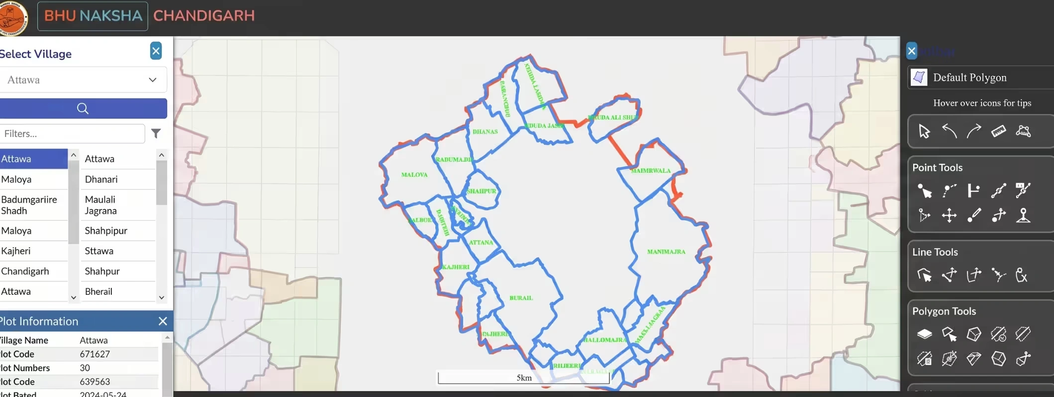
Bhu Naksha Chandigarh refers to the digital land map or cadastral map system used to identify land parcels, boundaries, and plot-level location details in Chandigarh.
In simple words, it is a map-based view of land records.
A normal land record tells you who owns the land.
A land map tells you where the land is located and how the parcel is shaped.
That difference is important.
Record Type | What It Shows | Why It Matters |
Jamabandi / RoR | Ownership, rights, revenue details | Helps verify landholder details |
Mutation Record | Change in ownership after transfer | Shows whether new ownership is updated |
Khasra / Parcel Detail | Land parcel identification | Helps identify the exact plot |
Cadastral Map / Bhu Naksha | Plot boundary and map location | Helps verify physical land with official map |
Registry / Sale Deed | Legal transaction document | Shows sale or transfer between parties |
The Department of Land Resources explains that land records are maintained in both textual and spatial formats. Textual records include RoR, while spatial land records are maps that establish actual boundaries on the ground.
So, when you check a Chandigarh land map, you are not just looking at a drawing.
You are checking the spatial identity of the land.
Why Chandigarh Land Map Verification Is Important
- Chandigarh has a unique property structure.
- Some properties fall under urban estate records.
- Some are linked with village revenue records.
- Some connect with the Chandigarh Housing Board.
Some are part of municipal or planning layers.
The official Chandigarh LandStack page mentions multiple stakeholders, including the Estate Office, Revenue Department, Chandigarh Housing Board, Department of Urban Planning, Municipal Corporation, and NIC.
This means buyers should not assume that one document is enough.
Before you buy land in Chandigarh or nearby areas, verify the property from the right department.
A Chandigarh land map can help you check:
- Plot location.
- Plot shape.
- Nearby road access.
- Village parcel identity.
- Boundary alignment.
- Difference between seller claim and map record.
- Land use connection.
- Ownership linkage, where available.
Map-based verification becomes even more important when you are buying land near Chandigarh, such as near Mohali, New Chandigarh, Zirakpur, Mullanpur, Panchkula, or nearby agricultural belts.
Many buyers casually say “land in Chandigarh,” but the actual land may fall under Punjab or Haryana records.
That changes the portal, law, registry process, mutation flow, and land-use rules.
Official Portals and Departments for Chandigarh Land Records
Here are the main official sources users should know.
Purpose | Official Source / Department | What You Can Check |
Chandigarh land records | Chandigarh Revenue Department | Registration, mutation, Jamabandi, RoR details |
Map-linked land/property data | Chandigarh LandStack | GIS-based land/property integration and parcel identity |
Registration-related services | Sub-Registrar / NGDRS-linked services | Property registration, appointment, deed process |
Certified RoR services | Chandigarh Administration / Revenue Department | Certified ownership record services |
Offline help | Land records office Chandigarh / DC Office | Corrections, certified copies, disputes, official clarification |
The Chandigarh Revenue Department page clearly states that its website helps people access official land records such as registration, mutation, and Jamabandi. It also says users can view sanctioned mutations and Jamabandi of land in Chandigarh using owner name, khewat number, and khasra number.
The LandStack project also lists the Deputy Commissioner Office, Sector 17, Chandigarh, as the contact address for the project.
Step-by-Step Guide: How to Check Bhu Naksha Chandigarh Online
The exact screen flow may change as Chandigarh upgrades its digital land systems. Use this process as a practical guide.
Step 1: Visit the Official Chandigarh Land Records or LandStack Portal
Start with the official Chandigarh Administration or Revenue Department website.
Avoid random websites that ask for payment, Aadhaar, phone number, or personal information just to show a basic land map.
Use official portals first because land records are sensitive.
Step 2: Choose the Land Record or Map-Based Service
Look for options related to:
- Land records.
- Online RoR.
- Jamabandi.
- Mutation.
- Khasra details.
- GIS map.
- Land parcel map.
- LandStack.
- Cadastral map.
If you are checking how to buy Agricultural Land in Chandigarh online, the Revenue Department record may be more relevant.
If you are checking urban property, estate property, or institutional property, department-wise data may differ.
Step 3: Enter Property or Parcel Details
Depending on the available search option, enter one of the following:
- Owner name.
- Khewat number.
- Khasra number.
- Village name.
- Parcel ID, if available.
- Property ID, if available.
- Sector or estate property details, if applicable.
For village land, khasra and khewat details are usually more useful.
For urban property, property ID or estate records may matter more.
Step 4: View Land Record Details First
Before looking at the map, check the land record.
See whether the name, parcel number, and record type match the seller’s claim.
Check:
- Owner name.
- Khewat number.
- Khasra number.
- Area.
- Mutation status.
- Jamabandi entry.
- Remarks, if shown.
A map is useful only when the linked land record is correct.
Step 5: Open the Map or GIS View
If the portal gives a map view, open it.
You may see a land parcel map, cadastral map, GIS layer, or plot boundary map.
Check whether the selected parcel is highlighted.
Review the surrounding roads, neighbouring parcels, shape, and location.
Step 6: Download or Print the Map, If Available
Some portals offer download, print, or PDF options.
If the Bhu Naksha Chandigarh download option is available, save the map copy for your own due diligence file.
If download is not available, use the official print option if provided.
For legal use, ask the land records office or revenue department whether you need a certified copy.
Do not treat a screenshot as a final legal document.
Step 7: Match the Online Map With Physical Site
Visit the site.
Compare the online map with actual boundaries.
Check road access.
Speak to neighbours if needed.
Confirm whether the seller is showing the same plot as the official map.
If the deal value is high, hire a local surveyor or get help from the revenue office.
Details You Need Before Checking Chandigarh Plot Map Online
Keep these details ready before using any online land record search Chandigarh service.
Detail | Why It Is Needed |
Owner name | Helps search Jamabandi or RoR |
Khewat number | Useful for landholding record search |
Khasra number | Helps identify exact land parcel |
Village name | Needed for village revenue land |
Property ID | Useful for urban/estate property |
Old registry copy | Helps match transaction history |
Mutation reference | Helps verify ownership transfer |
Sector or locality | Useful for urban location filtering |
Seller identity proof | Needed to match ownership claim |
For buyers, the best approach is simple:
- First check the record.
- Then check the map.
- Then check the registry.
- Then visit the site.
- Then pay.
- Do not reverse this order.
Bhu Naksha Chandigarh vs Jamabandi Chandigarh
Many users confuse Bhu Naksha with Jamabandi.
They work together, but they are not the same.
Point | Bhu Naksha / Land Map | Jamabandi / RoR |
Main Purpose | Shows plot boundary and map location | Shows ownership and rights record |
Format | Spatial / GIS / cadastral map | Textual land record |
Useful For | Boundary and plot identification | Ownership verification |
Search Details | Khasra, parcel, village, map layer | Owner name, khewat, khasra |
Legal Importance | Supports location verification | Supports revenue ownership verification |
Buyer Use | Confirms where the land is | Confirms who holds rights |
A safe buyer checks both.
Only checking Jamabandi may tell you the owner, but not the exact ground location.
Only checking the map may show you the plot, but not whether the seller has legal rights.
Can You Download Cadastral Map Chandigarh Online?
In many cases, users can view map-based land details online.
Download availability depends on the specific department, portal feature, and record type.
The Department of Land Resources identifies cadastral maps and spatial data as part of citizen-centric land services available through State and UT land record systems.
For Chandigarh, use the official Revenue Department and LandStack-related services first.
If the portal provides a download or print option, download the map.
If it does not, visit the relevant office and ask for an official or certified copy.
For legal work, loan processing, court matters, partition, demarcation, or registry disputes, a certified record is safer than an online screenshot.
Also Read: Chandigarh Circle Rates 2026: Complete Guide for Buyers
What to Check on a Chandigarh Land Parcel Map
When you view a Chandigarh property map, check these details carefully:
Map Detail | What It Helps You Verify |
Plot boundary | Whether the land shape matches seller claim |
Parcel location | Whether the site shown is the same land |
Road access | Whether the land has practical entry |
Neighbouring parcels | Whether there may be boundary confusion |
Village or sector layer | Whether the land falls in the right jurisdiction |
Land use layer, if visible | Whether the land use matches buyer intent |
Parcel ID or khasra | Whether map and record are connected |
Area | Whether map area and document area are aligned |
A map does not replace legal verification.
But it catches many early red flags.
Common Red Flags While Checking Chandigarh Land Map
Be careful if you notice these issues:
- The seller does not share khasra, khewat, or property ID.
- The plot shown physically does not match the online map.
- The land area in registry and map looks different.
- The land has no clear access road.
- The boundary overlaps with another parcel.
- The land is shown under a different village or department.
- The Jamabandi does not show the seller’s name.
- Mutation is not updated.
- The seller says, “No need to check records.”
- The price is too low for the location.
- These signs do not always mean fraud.
- But they mean you should slow down.
Checklist Before Buying Land in Chandigarh
Use this checklist before you buy land in Chandigarh or nearby areas.
Verification Point | Checked? |
Seller identity verified | ☐ |
Ownership record checked | ☐ |
Jamabandi / RoR reviewed | ☐ |
Mutation status checked | ☐ |
Khasra / parcel number matched | ☐ |
Bhu Naksha or cadastral map checked | ☐ |
Registry chain verified | ☐ |
Land use checked | ☐ |
Boundary physically verified | ☐ |
Road access confirmed | ☐ |
Encumbrance or legal dispute checked | ☐ |
Department jurisdiction confirmed | ☐ |
Sub-Registrar process checked | ☐ |
Legal expert reviewed documents | ☐ |
Final payment held until verification | ☐ |
This checklist is especially important for high-value plots, inherited properties, village land, and agricultural land for sale near Chandigarh.
Buying Land in Chandigarh vs Near Chandigarh: Know the Difference
Many buyers search for buy land in Chandigarh, Chandigarh residential plot for sale, and agricultural land for sale near Chandigarh.
But legally, these can be very different searches.
Location Type | Possible Record System | Buyer Caution |
Chandigarh UT urban property | Estate Office / municipal / department records | Check department-specific property record |
Chandigarh village land | Revenue Department records | Check Jamabandi, mutation, khasra |
New Chandigarh / Mullanpur | Punjab land records | Do not use Chandigarh records |
Panchkula-side land | Haryana land records | Use Haryana Jamabandi/map systems |
Mohali / Zirakpur / Kharar | Punjab land records | Check Punjab registry and revenue records |
This matters because a broker may market land as “near Chandigarh,” but the legal record may fall under Punjab or Haryana.
Before you pay token money, confirm the exact village, district, state, and revenue jurisdiction.
How 2Bigha Helps Buyers Explore Verified Land Opportunities
Most property websites show photos first.
But land buyers need location clarity first.
That is why 2Bigha focuses on a land-first discovery experience.
With 2Bigha, buyers can explore land through map-based listings, compare locations, and shortlist properties based on practical land details instead of only images and broker claims.
For users searching for verified land for sale in Chandigarh, plots near Chandigarh, or agricultural land around the tri-city region, 2Bigha can support a better discovery journey.
How 2Bigha Adds Value
You can explore land visually through map-based listings.
- You can compare nearby land parcels.
- You can understand the location context before visiting the site.
- You can shortlist land more confidently.
- You can reduce time wasted on unclear listings.
- You can connect with more serious buying or selling opportunities.
For sellers, agents, and landowners, 2Bigha’s subscription plan can help improve listing visibility, present land details better, and reach buyers who actively search for land, plots, farmhouses, and investment parcels.
A subscription-led listing approach also helps serious sellers stand out from casual or incomplete listings.
But here is the honest advice:
- 2Bigha can make discovery easier.
- Official records make verification stronger.
- Use both.
How Sellers Can Prepare a Land Listing in Chandigarh
If you want to sell lands in Chandigarh or nearby areas, prepare your documents before listing.
- A serious buyer will ask for them.
- Keep these ready:
- Clear location details.
- Parcel or khasra number, if applicable.
- Jamabandi or ownership record.
- Mutation record.
- Registry copy.
- Property ID, if available.
- Land map or parcel map.
- Road access photos.
- Boundary photos.
- Nearby landmark details.
- Land use details.
- Expected price.
- Seller identity proof.
- A clean listing gets better enquiries.
- A verified listing gets more trust.
A map-based listing on 2Bigha can help sellers present land with better clarity, especially when the buyer is comparing multiple lands.
Offline Verification: When Should You Visit the Land Records Office Chandigarh?
- Online tools are useful.
- But some cases need offline verification.
- Visit the relevant office if:
- The map is not loading.
- Your parcel does not appear online.
- The owner's name is incorrect.
- Mutation is pending.
- The boundary is disputed.
- The khasra or khewat number is unclear.
- The property falls under multiple authorities.
- You need a certified copy.
- The seller has only old records.
- The property is inherited or jointly owned.
The LandStack contact page lists the Deputy Commissioner Office, Sector 17, Chandigarh, UT 160017, as the address connected with the project.
For property registration and land record services, Chandigarh’s Revenue Department remains an important official source.
Documents to Verify Before Buying Plot or Land in Chandigarh
Before finalizing any land deal, ask for these documents.
Document | Why It Matters |
Sale deed / registry | Shows legal transfer history |
Jamabandi / RoR | Shows ownership and rights record |
Mutation record | Shows updated ownership in revenue records |
Khasra / parcel detail | Confirms plot identity |
Cadastral map / Bhu Naksha | Confirms map location and boundaries |
Property tax receipt | Helps verify municipal status, if applicable |
Building plan or land use approval | Important for urban property |
Encumbrance details | Helps detect loan, lien, or legal burden |
Seller ID and PAN | Confirms seller identity |
Power of attorney | Required if someone else is selling |
NOC, if applicable | Needed for certain property categories |
Legal heir documents | Needed in inherited property cases |
Never buy land only because the location looks good.
Buy land only when the documents are clean.
Bhu Naksha Chandigarh for Property Investment
Chandigarh and the surrounding tri-city region attract strong property interest because of planned development, connectivity, institutions, commercial demand, and lifestyle value.
- But land investment needs patience.
- Before investing, check:
- Exact jurisdiction.
- Land use.
- Map location.
- Road connectivity.
- Ownership record.
- Mutation status.
- Registration history.
- Future development potential.
- Nearby pricing.
- Resale demand.
- If the property is outside Chandigarh UT, use the correct state portal.
- For example, Punjab and Haryana have their own land record systems. Do not use Chandigarh records for land located in Mohali, Panchkula, Zirakpur, or Mullanpur.
- A good investor verifies before negotiating.
- A risky investor negotiates before verifying.
- Do not be the second type.
Quick Summary: Bhu Naksha Chandigarh Download Process
Step | Action |
1 | Visit official Chandigarh Revenue Department or LandStack-related portal |
2 | Choose land record, RoR, Jamabandi, or map service |
3 | Enter owner name, khewat number, khasra number, village, or parcel details |
4 | Check ownership or record details first |
5 | Open map/GIS/cadastral view if available |
6 | Verify plot boundary, location, and neighbouring parcels |
7 | Download or print if the portal provides the option |
8 | Visit the site and match physical boundary |
9 | Get certified copies or legal review before final deal |
Final Words
Bhu Naksha Chandigarh is useful for anyone dealing with land, plots, or map-based property verification.
- It helps buyers understand where a land parcel is located.
- It helps sellers present property with more confidence.
- It helps investors avoid blind decisions.
But online maps are only one part of due diligence.
Before buying land in Chandigarh, always verify the land map with Jamabandi, mutation, registry, ownership record, physical site inspection, and legal review.
- For discovery, use a land-focused platform like 2Bigha.
- For verification, use official Chandigarh land record sources.
- For final purchase, use legal due diligence.
- That is the safest way to buy or sell land in Chandigarh.
FAQs on Bhu Naksha Chandigarh
1. What is Bhu Naksha Chandigarh?
Bhu Naksha Chandigarh refers to the digital land map or cadastral map used to view land parcel location, plot boundaries, and map-based property details in Chandigarh. It helps buyers and sellers compare official map data with physical land location.
2. How can I view the Chandigarh land map online?
You can check Chandigarh land map-related details through official Chandigarh land record platforms such as the Revenue Department and LandStack-linked services. Search using owner name, khewat number, khasra number, village, or property details, depending on the portal options available.
3. Can I download Bhu Naksha Chandigarh online?
If the official portal provides a download or print option, you can download or print the map for reference. For legal use, certified copies may be required from the relevant land records office or revenue department.
4. What details are needed to check the Chandigarh plot map online?
You may need owner name, khewat number, khasra number, village name, property ID, sector details, or parcel ID. For village land, khasra and khewat details are usually helpful. For urban property, department-specific property details may be required.
5. Is Bhu Naksha enough to prove land ownership?
No. Bhu Naksha shows map or boundary information. Ownership must be verified through Jamabandi, RoR, mutation record, registry documents, and seller identity. A land map supports verification but does not replace legal title checking.
6. What is the difference between Jamabandi and Bhu Naksha?
Jamabandi is a textual land record that shows ownership and rights details. Bhu Naksha is a spatial map that shows land parcel location and boundaries. Buyers should check both before purchasing land.
7. Where is the land records office in Chandigarh?
The Chandigarh LandStack contact section lists the Deputy Commissioner Office, Sector 17, Chandigarh, UT 160017. For official land record, mutation, and certified copy matters, users should approach the relevant Chandigarh revenue or registration office.
8. Can I use Chandigarh land records for land near Mohali or Panchkula?
No. If the land falls in Mohali, New Chandigarh, Zirakpur, Mullanpur, or Panchkula, it may come under Punjab or Haryana land records, not Chandigarh UT. Always confirm the exact state, district, village, and revenue jurisdiction.
9. How does 2Bigha help in buying land around Chandigarh?
2Bigha helps buyers explore land through map-based listings and compare location-based opportunities more clearly. Sellers can use subscription plans to improve listing visibility and present land details more professionally.
10. What should I verify before buying land in Chandigarh?
Check Jamabandi, RoR, mutation, registry chain, cadastral map, physical boundary, land use, road access, seller identity, encumbrance details, and legal title. Never rely only on photos or broker claims.
Disclaimer: This image is for illustrative purposes only. We do not claim ownership; all rights belong to respective owners. Contact us for credit or removal.