Key Takeaways
- Karnataka’s Survey, Settlement and Land Records wing is moving toward fully digital land survey operations by the end of 2026, with online applications, digital sketches, boundary access, and reduced physical office visits.
- The state is backing this shift with GIS-based records, Bhoomi 8.0, Land-Stack integration, Kaveri 3.0, and digitisation of old Tippan, FMB, and atlas records.
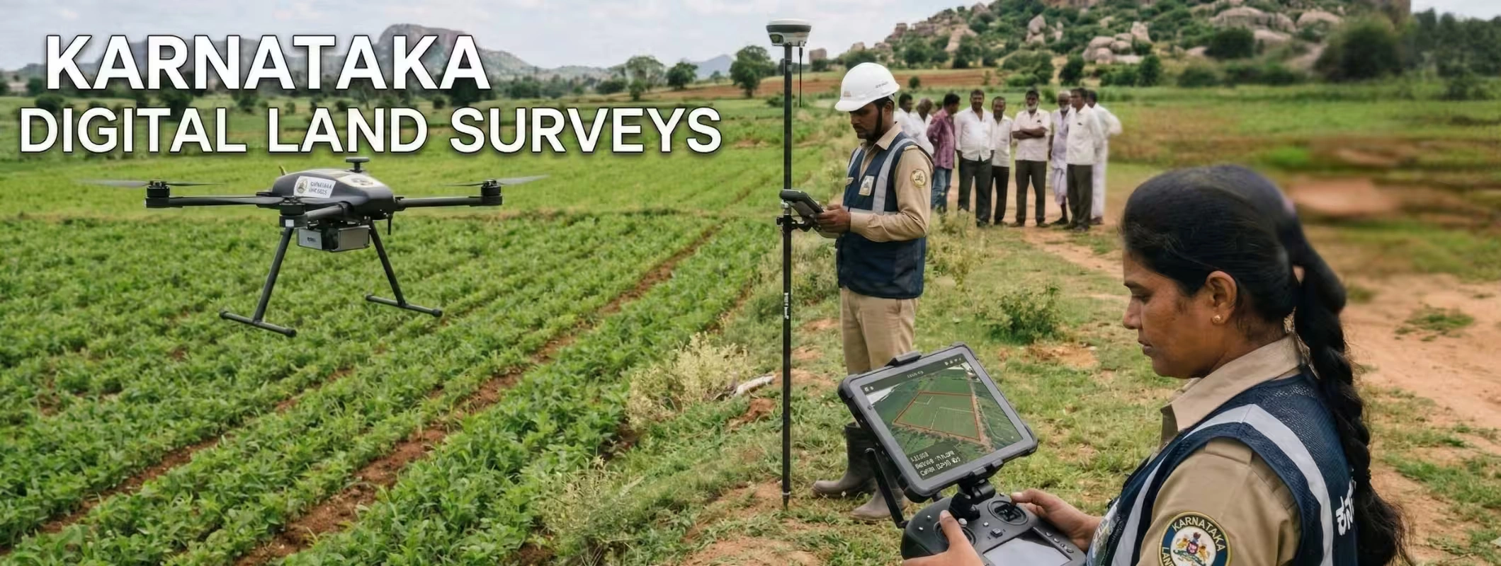
- Karnataka has also rolled out GPS rover-based surveys, which officials say are far faster and more precise than the old chain-and-staff method.
- For buyers and investors, this can mean clearer boundaries, faster due diligence, fewer middlemen, and lower risk of boundary or subdivision disputes.
Karnataka’s Digital Land Survey Push is a Big Deal
Buying land in India has never been just about location and price. It is also about boundaries, title clarity, survey records, mutation status, access roads, and whether the land on paper matches the land on the ground. In Karnataka, that gap has often created delays, confusion, and disputes. That is exactly why the state’s push toward fully digital land surveys matters so much for buyers, landowners, and investors.
Karnataka’s Survey, Settlement and Land Records department aims to complete full digitisation of its operations by the end of 2026. Once this matures, citizens should be able to apply for land surveys, track status, generate sketches, and access boundary information online without repeatedly visiting government offices.
That is not a small admin reform. It is a structural change in how land gets verified, mapped, recorded, and transacted across the state. For anyone planning to buy agricultural land, farmhouse land, plotted land, or long-term investment land in Karnataka, this is the kind of reform that can directly affect risk, speed, and confidence.
What Does “Fully Digital Land Surveys” Actually Mean?
In simple terms, Karnataka is shifting land survey work from a paper-heavy, office-dependent, manually measured process to a system that uses online workflows, GIS mapping, geospatial records, digitised legacy documents, and modern survey hardware.
The state has said that old survey records, including difficult-to-read historic documents and Tippanis, are being converted into accessible digital formats. These records are then being connected to geospatial revenue maps so land boundaries can be measured and verified more accurately.
Karnataka’s 2026–27 Budget adds more weight to this plan. It says the state will integrate data from Bhoomi, Mojini, Kaveri, E-Swathu, and E-Asthi under a Karnataka Land-Stack hosted on a GIS-based digital platform. It also confirms that Bhoomi will be upgraded to Bhoomi 8.0, linked with more than 10 departments, while Kaveri 3.0 is being developed to support AI-based paperless registration.
Why Karnataka is Accelerating This Reform
This move is not coming out of nowhere. Karnataka has been building toward it for some time. The 2024–25 Budget had already announced modern survey equipment, drone support for district survey offices, Digi-Kandaya expansion, and modernization of land survey record rooms.
By 2025, the government was already describing digital land records, simplified phodi processes, Bhoo Suraksha digitisation, and software integration across departments as core governance priorities. State publications also said 100 crore pages of land records had been digitised under Bhoo Suraksha, and that Nanna Bhoomi and e-Swathu initiatives were being used to improve access and ownership documentation.
In other words, the 2026 digital survey announcement is the next phase of a broader land-record modernization strategy, not a one-off headline.
Manual Surveys vs Digital Surveys in Karnataka
| Aspect | Older Process | Digital Direction by 2026 |
| Survey application | Often required office visits and manual follow-up | Online applications and status tracking through digital systems |
| Boundary verification | Depended heavily on legacy maps and manual interpretation | Geospatial digital maps, GPS-based verification, and digital sketches |
| Survey tools | Chain-and-staff method, slower and labour-intensive | GPS rover devices linked to CORS for faster, high-precision surveys |
| Land records | Fragmented across departments and many older paper records | GIS-based Land-Stack integrating Bhoomi, Mojini, Kaveri, E-Swathu and E-Asthi |
| Buyer confidence | More room for mismatch, delay, and middlemen | Better transparency, traceability, and easier verification |
The Technology Behind Karnataka’s Land Survey Modernisation
One of the most important upgrades is the use of GPS rover devices. Karnataka has begun replacing the old chain-and-staff survey method with rover-based equipment integrated with Continuous Operating Reference Stations (CORS). Officials told the media the system can deliver a margin of error of just 1–2 centimetres and can work nearly 20 times faster than conventional surveying in some cases. The state’s own 2025 government publication also said 5,000 rovers had been deployed, survey sketch applications were being resolved within 30 days, and crores of Akarband and Hissa sketches had already been digitised.
Another key layer is ULPIN, or the Unique Land Parcel Identification Number. The Government of India describes ULPIN as a 14-digit identification number assigned to land parcels using geo-referenced coordinates. Its purpose is to create a single, authoritative identity for a parcel of land, improve transparency, and reduce boundary disputes. Karnataka is listed among the states where ULPIN has been rolled out.
This matters because once parcels are mapped, tagged, and linked across systems, it becomes harder to manipulate boundaries, subdivide land informally, or push unclear land into transactions without stronger scrutiny. That is exactly the kind of structural improvement serious investors look for.
What This Means for Land Buyers in Karnataka
For ordinary buyers, the biggest benefit is clarity before payment. When survey data, parcel identity, RTC records, sketch access, and digital maps work together, buyers get a stronger base for checking whether the land they are seeing matches the land being sold.
This is especially important in cases involving agricultural land, family partitions, phodi, inheritance-based transfers, road-access claims, or part-survey-number sales. These are the situations where record mismatch usually creates trouble later, not at the time of verbal negotiation. Karnataka’s own policy direction recognises that the gap between textual records and spatial records has been a real issue, which is why it has pushed pre-mutation sketching, integrated phodi, digitisation, and geo-referenced maps.
For a buyer, this means one practical thing: digital land surveys do not remove the need for due diligence, but they make good due diligence easier.
What This Means for Investors
For investors, the upside is even bigger. Land investment works best when entry risk is low, holding confidence is high, and exit is smoother. A digital survey ecosystem improves all three.
First, it can help investors compare parcels more confidently because location, size, boundary, and adjoining details become easier to verify. Second, it reduces dependence on opaque offline processes and local middle layers.Third, when registration, survey, and land-record systems start speaking to each other, it becomes easier to assess whether a land parcel has future development potential or hidden compliance issues.
This does not mean every land deal in Karnataka suddenly becomes risk-free. Title disputes, conversion issues, access disputes, local zoning conditions, and ground-level possession still matter. But it does mean the state is building a better verification backbone, and that is positive news for long-term land investment.
Existing Digital Tools Buyers Should Already Know
Karnataka is not starting from zero. It already has multiple digital layers that buyers should know.
Bhoomi is the state’s flagship land-record management system, created to digitise RTC and mutation-linked records. Official district information says manual RTCs were digitised under this system and land record changes are processed through the database under the Karnataka Land Revenue framework.
Mojini V3 already allows the public to apply online for several survey-related services and survey records by paying fees online. The portal also supports report viewing.
Dishaank is a mobile GIS application that helps users identify survey numbers and land details using mobile GPS and interactive map-based data.
As Karnataka moves toward fully digital surveys, these tools are likely to become even more useful in day-to-day land verification.
Checklist: Before You Buy Land in Karnataka
Before you finalise any deal, check these points:
- RTC/Pahani details match seller details.
- Survey number and subdivision details match the parcel shown on ground.
- Mojini sketch, survey records, or related boundary documents are available where required.
- Mutation status is updated and there are no unresolved inheritance or partition gaps.
- ULPIN or parcel-based digital mapping is checked wherever available.
- Buffer zones, lake beds, forest-related issues, and restricted areas are reviewed carefully. Officials have said geospatial maps will help flag ecologically sensitive areas and illegal proposals.
- Ground visit, possession verification, and legal review are still completed before token payment or registration.
What is 2Bigha and How it Helps Buyers and Investors?
2Bigha is a land-focused real estate platform built around buying, selling, and discovering agricultural land and farmland across India. Its platform highlights searchable listings, map-led exploration, price visibility, and property insights that help users compare opportunities more practically.
For buyers, 2Bigha helps by bringing land options onto one searchable platform, making it easier to compare area, price, location, and listing details without depending only on scattered offline leads. For investors, that matters because better comparison often leads to better decisions.
2Bigha is also useful for people who want a more guided land discovery journey. Its ecosystem includes property discovery, selling support, and a separate investment-facing proposition that positions land as an alternative asset class with curated opportunities and a more managed approach.
In a market where digital land records are becoming more important, platforms like 2Bigha can add value by helping buyers and investors shortlist opportunities faster, compare locations smarter, and approach land investment with more structure instead of guesswork.
Final Word
Karnataka’s move toward fully digital land surveys by the end of 2026 is more than a technology upgrade. It is a trust upgrade for the land market. When records become easier to access, surveys become more accurate, parcel identity becomes stronger, and registration becomes more connected, the market becomes easier to navigate for genuine buyers and more difficult to exploit for bad actors.
For farmers, landowners, and buyers, this can reduce delay and confusion. For investors, it can improve diligence and decision-making. And for the broader real estate ecosystem in Karnataka, it signals a future where land transactions become more transparent, more searchable, and more data-driven.
If you are planning to buy land in Karnataka, now is the right time to think beyond price and location. Start looking at digital verification, parcel clarity, survey accuracy, and platform-led discovery. That is where the next phase of smarter land buying is heading.
Frequently Asked Questions (FAQs)
1. When will Karnataka fully digitise land surveys?
The current target reported by officials is by the end of 2026.
2. What is ULPIN in land records?
ULPIN is a 14-digit unique land parcel identification number based on geo-referenced coordinates. It is meant to improve parcel identification, transparency, and integrated land services.
3. What is the benefit of digital land surveys for buyers?
Digital surveys can improve boundary accuracy, reduce delays, support online access to records, and lower the chances of confusion caused by mismatched or unclear land data.
4. Can I apply for land survey services online in Karnataka?
Yes. Karnataka’s Mojini V3 portal already supports online applications for several survey-related services and survey records.
5. Is Bhoomi the same as a land survey portal?
Not exactly. Bhoomi is Karnataka’s flagship land records management system, while survey-related workflows are also connected to tools like Mojini and GIS-based systems.